As Cyclone ‘Senyar’ a weather system that intensified in the Strait of Malacca—moved away from Indian shores, another low-pressure area over the southwest Bay of Bengal has strengthened into Cyclonic Storm ‘Ditwah,’ which is projected to impact Tamil Nadu, Puducherry, and adjoining south Andhra Pradesh coast by November 30, the India Meteorological Department (IMD) has announced.
In the early hours of Thursday, the IMD reported that Cyclone Senyar was positioned 850 km southeast of Car Nicobar the northernmost island of the Nicobar Islands and was forecast to weaken into a depression by evening.
Meanwhile, another weather system simultaneously developed over the southwest Bay of Bengal and adjoining areas of southeast Sri Lanka and Equatorial Indian Ocean, according to the IMD.
Formation of Cyclone ‘Ditwah’
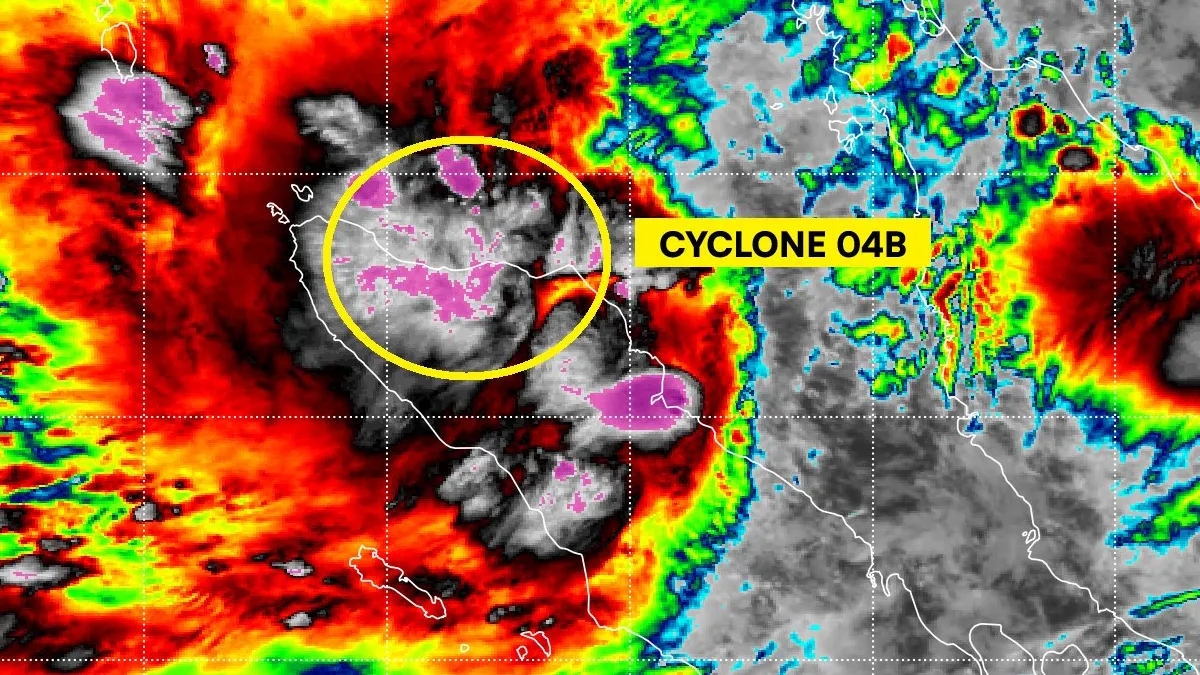
In its latest update on X, the IMD confirmed that Cyclone Ditwah formed over the southwest Bay of Bengal and was positioned close to Pottuvil approximately 700 km south-southeast of Chennai, Tamil Nadu.
The system is expected to move north-northwest and reach the coasts of north Tamil Nadu, Puducherry, and south Andhra Pradesh by early November 30, the IMD stated.
The cyclonic storm has been named ‘Ditwah,’ a designation submitted by Yemen according to the roster that lists names of tropical cyclones over the north Indian Ocean.
“Cyclone Ditwah formed over the SW Bay of Bengal near 6.9°N/81.9°E at 1130 IST today. It lay close to Pottuvil, ~90 km SSE of Batticaloa and ~700 km SSE of Chennai. The system will move NNW and reach off North Tamil Nadu–Puducherry–south AP coasts by early 30 Nov,” the IMD posted at 2:56 pm.
Multiple districts in Tamil Nadu, including Chennai, Nagapattinam, Thiruvallur, and Thanjavur, have been placed under yellow and orange alerts by the IMD for November 27, 28, and 29.
‘Rare’ Cyclone Senyar
Cyclonic storm Senyar originated in the Strait of Malacca, a narrow waterway situated between Peninsular Malaysia and the Indonesian island of Sumatra, with Singapore positioned at its southeastern edge. The northwestern portion of the Strait of Malacca connects directly to the Andaman Sea.
Cyclone Senyar moved away from Indian territory and was reportedly heading toward Malaysia, near Sumatra, according to Malaysian news outlet NST, citing MetMalaysia director-general Mohd Hisham Mohd Anip.
Weather experts and observers have described Cyclone Senyar as ‘rare,’ marking the first time a weather system of cyclonic storm strength has been documented in the Strait of Malacca.
“The last one, a tropical depression, occurred in 2017 and affected Penang. But for a system to reach tropical storm intensity, as we are now seeing near Sumatra, this is a first,” Mohd Hisham Mohd Anip explained.
MetMalaysia issued a tropical storm alert, with the system detected at latitude 4.5 degrees north and longitude 97.9 degrees east.
“It is moving west-southwest at 9kph with maximum sustained winds of 83kph. Its closest point to Malaysia is approximately 284km southwest of George Town, Penang. The intensification is expected to bring continuous heavy rain, strong winds and rough seas to several northern states,” the advisory stated.
Cyclonic storm Senyar, now anticipated to affect Northern Sumatra with heavy rainfall and possible flooding, has been characterized as ‘rarest of rare’ by many observers.
One X user with the handle @chennaisweather commented, “even if short lived this cyclone remains one of the rarest ever recorded near the Malacca Strait, making this a historic meteorological event”.
“Based on the latest forecast track from the US Joint Typhoon Warning Center (JTWC) could become the first tropical cyclone in recorded history to make landfall in the western coast of Peninsular Malaysia by later midnight, and the second overall — after Typhoon #Vamei in 2001,” another user posted on X.
-

-

-

-