Hidden In British Archives: Scientists Decode 200-Year-Old Indian Scroll That Helped Sailors Cross One Of The World’s Toughest Seas
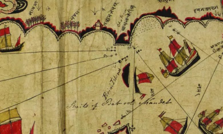
Researchers from the University of Exeter in the United Kingdom have decoded a centuries-old Gujarati navigational chart, revealing how Indian Ocean sailors found their way without modern maps or instruments. For nearly two centuries, the ancient Indian map sat quietly in the archives of Britain’s Royal Geographical Society, admired as an unusual old map but never fully understood.
Now, researchers have unlocked its hidden language and discovered that the delicate paper scroll was far more than a map — it was a sophisticated navigation guide that helped Indian sailors cross the Red Sea and Gulf of Aden long before GPS and compasses became widespread, or European-style charts came to dominate the seas.
The scroll, created by Kachchhi or Gujarati seafarers in the late 18th or early 19th century, offers rare evidence that Indian Ocean mariners developed their own highly effective navigation system, one rooted in local knowledge, stars, and memory.
The Map That Wasn’t Meant To Look Like A Map
To modern eyes, the chart appears distorted. The Red Sea is angled differently from how it appears on modern maps, coastlines seem compressed, and there are no obvious latitude-longitude grids. For decades, scholars assumed these were flaws, concluding the chart lacked scientific precision.




The new study, however, has revealed that it was in fact an “effective aide memoire.” Researchers found that the unusual design was intentional. The scroll, just 25 centimetres wide, was built for use aboard ships — sailors could unroll only the section they needed while keeping the rest protected from wind and water.
Rather than attempting to replicate geography with perfect accuracy, it prioritised what navigators actually needed: sailing directions, landmarks, islands, reefs, and ports.
Hidden Codes Finally Deciphered
One of the biggest breakthroughs came when researchers successfully translated all 66 Devanagari place names on the chart for the first time. Earlier historians had identified only about half of them.
The team also decoded astronomical information that had gone unnoticed for almost 190 years. Rather than lacking latitude data, as previously believed, the scroll actually encoded latitude through stellar navigation, allowing experienced sailors to determine their position at sea.
Researchers also found that 29 carefully drawn rhumb lines served multiple purposes, from indicating coastal direction to plotting safe routes across open water and into ports.
A Guide Written For Those Who Already Knew The Sea
Unlike modern navigation charts designed for anyone to read, this document assumed its users already possessed generations of maritime knowledge. It functioned as what researchers describe as an “aide memoire” — a portable reference that refreshed a navigator’s memory rather than teaching someone how to sail.
The scroll contains more than 180 islands, reefs, religious buildings, flags, and coastal landmarks, helping experienced sailors pinpoint their location while travelling between India, Arabia, and the Horn of Africa. Its religious illustrations also hint that its navigator was likely Muslim, while the flags mark important political and trading centres.
“This is a rich and effective navigational reference work: its stellar information allowed sailors to know their latitude and set sailing directions; its many place names and topographical information enabled them to locate themselves precisely; its religious buildings suggest the navigator’s Muslim faith; and its flags suggesting nodes of political and fiscal action,” said Professor John Cooper, from the University of Exeter’s Institute of Arab and Islamic Studies, who led the research.
How Did The Indian Map End Up In A British Archive?
According to the university, the chart entered British hands in 1835, when explorer Alexander Burnes acquired it from an unnamed sea captain in Kachchh while serving with the East India Company.
Burnes recognised it as an extraordinary maritime document and donated it to the Royal Geographical Society, calling it a “form a specimen of naval surveying … unequalled in any of the cabinets of Europe.” Yet even he misunderstood its true purpose.
Over the following 180 years, the chart was examined several times — in 1947, 1987, 2002, 2012, and 2022 — yet scholars continued to overlook its practical role as a working navigational tool. Only now, using fresh linguistic analysis and modern cartographic techniques, have researchers reconstructed the chart’s full geographical meaning.
Rewriting Indian Ocean History
The findings challenge long-held assumptions that sophisticated maritime navigation in the Indian Ocean depended primarily on European mapping traditions. Instead, they reveal an indigenous system refined over centuries, one that relied on experience, stellar observation, and an intimate understanding of local waters rather than mathematical projections.
Far from being an inaccurate map, the scroll was an elegant solution to a sailor’s greatest challenge: carrying centuries of navigational knowledge across some of the world’s most demanding seas, in a document small enough to fit aboard a wooden ship.