New Delhi: The Indian Space Research Organisation (ISRO) has released satellite images that document the extensive destruction following a 7.7 magnitude earthquake that struck Myanmar on Friday, impacting neighboring nations as well.
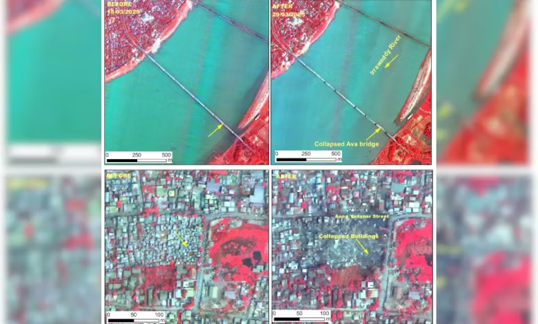
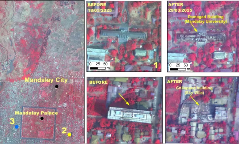
Utilizing its advanced Cartosat-3 Earth imaging satellite, which provides images at resolutions finer than 50 centimeters from an altitude of 500 kilometers, ISRO captured detailed photographs of the disaster. The images clearly show the collapse of a massive bridge over the Irrawaddy River, significant damage at Mandalay University, and the ruin of the Ananda Pagoda.
Launched in 2019, the third-generation, agile, advanced Cartosat-3 satellite is rarely featured in public releases due to its sophisticated capabilities, according to ISRO.
Also read: “India Ready To Offer Assistance”: PM Modi On Myanmar, Bangkok Earthquake


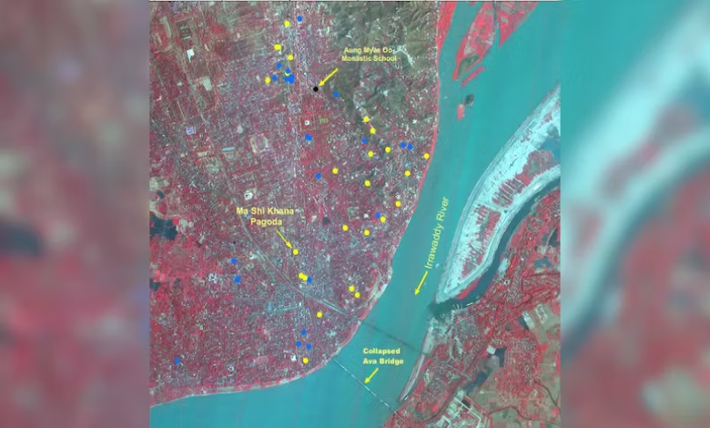
The National Remote Sensing Centre, an ISRO division, reported that post-disaster imagery was collected on Saturday over Mandalay and Sagaing. Data from March 18 was also analyzed to assess the extent of the damage, which was particularly severe in Mandalay, Myanmar’s second-largest city.
The quake, with a magnitude of 7.7, was followed by a 6.4 aftershock. Its epicentre, located 10 kilometers deep near the Sagaing-Mandalay border, resulted in widespread destruction across Mandalay, while the tremors were felt in the capital, Naypyidaw, and other areas. The seismic activity even extended into parts of northern Thailand, including Chiang Mai, where reports of damage emerged.
The satellite images reveal that major landmarks in Mandalay—including the Sky Villa, Phayani Pagoda, Mahamuni Pagoda, Ananda Pagoda, and the University of Mandalay—suffered extensive damage, either partially or completely. In Sagaing, structures such as the Ma Shi Khana Pagoda, several monasteries, and other buildings were also affected.
Also Read: Myanmar Earthquake Claims 1,644 Lives as Global Aid Pours In and Rebels Halt Clashes
Moreover, the historic Ava (InnWa) Bridge over the Irrawaddy River near Inn Wa City was seen collapsed, with additional signs of liquefaction and cracks evident in the flood plains along the river.
ISRO’s assessment highlights Myanmar’s location near the convergent boundary of the Indian and Eurasian plates, where the Indian Plate advances northward at about 5 centimeters per year. The country’s proximity to several smaller fault zones, including the major Sagaing Fault—a strike-slip fault facilitating lateral plate motion—likely contributed to the seismic event, possibly releasing built-up stress along this fault or its accessory faults.
In response, India was among the first to dispatch rescue teams and offer aid to Myanmar.